Shavehead Lake has a long history that includes camping, camp grounds and cabin rentals. At the turn of the 19th to the 20th century there was a resort (as it was called then) of a few small cabins and store on the west arm of the lake called the “Shavehead Lake Resort.” For years families would come to Shavehead to relax and enjoy its beauty by renting one of the cabins. A second area on the north end (on the west arm of the lake) was the Fireside Camp. It encompassed the area where several newer homes have been recently built and the beach and A-frame conference center area that are now part of Camp Friendenswald. As late as the 1970’s, families enjoyed camping this area of the lake. In fact you can still see the old bath house in the trees on the west side of Peninsula Drive across from the Turtle Hill area. But the only remaining camp property (and one that most may know little about its history) is the Mennonite camp called Camp Friedenswald meaning “Peaceful Woods.” Camp Friedenswald was founded in 1949 in the tradition of the Mennonite Anabaptist heritage and is supported by Central District Conference of Mennonite Church USA. The camp specializes in providing programming such as summer camps, winter retreats, adult retreats and outdoor education as well as facility rentals for both large and small groups. In 1949, the original forty acres were purchased on Shavehead Lake to begin the camp. That same year 12 cabins were constructed along with 2 bath houses. A dining was yet to be built so campers ate their meals under a tarp attached to cabin 7 but had to lift their feet to let the water run downhill when it rained. From those meager beginnings a wonderful camp has grown into what we see today…but it was a long process. In 1953 a Dining hall was built with a kitchen and offices. Later (1957) a 10 unit staff house was built to house workers with a Chapel to follow in 1959. Also in 1959 a building, known as Tubby’s Store, was purchased on the corner of Union Road and Peninsula Drive. It provided space for the Camp Director and for winter campers…thus opening the camp to year round camping. That parcel was eventually sold, but the owner donated the land back to the camp after a fire consumed the building. The 1960’s and 70’ brought growth and expansion as new land was acquired along Union Road, additional housing constructed on the main campus and with the expansion of the dining hall, laundry and maintenance areas. It was also during this time that the Fireside Camp property on Peninsula Drive was acquired along with another woodland area (Eby’s Woods) that has since been declared by the Nature Conservancy as one of the top 10 old growth red oak forests in Michigan. In spite of economic uncertainties during the1980’s, the camp continued to experience times of rebuilding, consolidating and some additional growth. A number of new programs were begun, additional facelifts to buildings completed, 15 acres acquired around the Shavehead hollow and a new entry completed. The new Tamarak Lodge overlooking the Tamarak forest (across the fen) was constructed. It was also during this time (1989) after years of negotiating that the camp also acquired the undeveloped area around the Northeast corner (of the east arm) of the lake from Ed Lowe…the founder of Kitty Litter. We all now enjoy this natural space when we anchor our boats to swim in that area of the lake or walk the trails the camp has around the fen and through its woods. Over the last 20 years additional lands have been donated or acquired along both sides of Peninsula Drive bringing the camp additional opportunities for programming and future growth. Today Camp Friedenswald has over 340 acres of forest, which includes a red oak preserve, marsh, fresh-water fen and meadow. Friedenswald hosts year-round weekend and weekday church retreats, family reunions, youth groups, conferences and banquets and can accommodate up to 250 people. It is truly a remarkable history written over the last 65 years through many the investment and care of many dedicated people. It is a wonderful neighbor and provides a stable natural habitat on a large portion of the lake for all to enjoy. You can read about this and more at the Camp Friedenswald website. www.friedenswald.org
|
Any history of our area would be incomplete if mention was not made of the unique role played by Underground Railroad in Cass County (and particularly Vandalia/Shavehead Lake). The Underground Railroad was a network of
'stations' (homes, carriage houses and barns) owned by Quaker abolitionists, as well as free black men and women and other sympathizers. Freedom seekers traveled at night to avoid being seen and were given refuge at these safe locations during daylight hours. The journey to Canada was long and difficult. They traveled on foot and were often hidden in wagons beneath bags of grain or hidden under the fake floorboards to keep from being detected. It is claimed that over 1500 freedom seekers passed through Cass County during this era on their way through Schoolcraft, Battle Creek, Jackson, Ann Arbor, Detroit and finally Windsor, Canada. There was so much UGRR activity in the area around Vandalia that it was known in Washington D.C. as "that hotbed of abolitionism". Between 1842 and 1847 there also developed a colony of fugitives who resided in small cabins of 5-10 acre plots of land provided by local Quakers. In exchange for clearing the land, freedom seekers could plant gardens, earn money and participate in local community activities. James E. Bonine, who built the Bonine House and Carriage House (pictured on page 6) on M-60 and Calvin Center Road, was one of the Quaker farmers who set aside land for a period of 5-10 years. Great Kentucky Raid In August of 1847 a group of thirteen Kentucky slave catchers arrived in Cass County. They broke into smaller parties and proceeded to various Quaker farms capturing nine former slaves. Word of the kidnapping spread quickly and a crowd of upwards of 300 Quakers, free blacks and other abolitionist townspeople gathered to stop the Kentuckians. A confrontation ensued at Odell's Mill in Vandalia. As weapons were brandished the Quakers present were credited with calming the situation before it escalated to further violence. Because they were severely outnumbered and believing the law at that time (Fugitive Slave Act of 1793) was on their side, the Kentuckians agreed to go to Cassopolis, post bond for their own freedom but still stand trial. (Legend is that one of the Kentucky wagons is at the bottom of Shavehead). There was a three day delay in the trial proceedings while the Kentuckians gathered the necessary documents to prove ownership of the captives. When the trial commenced, Quakers, free blacks and fugitives filed charges against the Kentuckians. The Commissioner found for the freedom seekers, saying the Kentuckians didn't have the correct paperwork. The freed captives, along with thirty-four other fugitives, immediately left for Canada on the UGRR. If you are interested in learning more visit the "Village of Vandalia Underground Railroad Days" July 12-13. In addition to the exhibits, tours are given of area homes and sites involved. **Much of this article was taken from Underground Railroad Society of Cass County Web site It began with the discovery in 1929 of large bones in a marl pit in the Chapel Hill Church area north of Union Michigan. These bones (including a 3 foot eleven inch femur) eventually proved to be from a mastodon that measured 10 feet 6 inches at the shoulder and a length of over 13 feet. They were found buried under almost 9 feet of undisturbed marl which is almost pure calcium carbonate, formed from the shells of fresh-water invertebrates and by direct precipitation from the water. The undisturbed condition of the marl beds showed the cadaver had been deposited before the marl was formed. Thus the skeletal remains dated to the beginning of the formation of a large body of water left as a large glacier receded north. This area apparently was termed “Lake Mogodore” by a then area resident named John Eby. The name “Mogodore” had earlier been applied to the narrow valley with a stream that winds southward from Shavehead Lake through and including several lakes to the south. The borders of Lake Mogodore are identified by a welldefined offshore terrace, often consisting of Marl, and in some places by low, wave-cut cliffs. The terrace stands between 35 and 40 feet above the present level of Shavehead Lake and at about the same height above Carter Lake. At Birch Lake, however, the terrace is only about 6 feet above lake level. At its greatest extent Lake Mogodore had a total length of about 6&1/2 miles and a maximum width of about 1 mile. It was irregular in shape and contained several islands. The present drainage starts with Birch Lake (to our north) which is the highest in the Mogodore Basin. It discharges southward into the western arm of Shavehead Lake. The outlet from Shavehead takes a south-easterly course and is joined by the drainage of Carter Lake at the head of the Mogodore Valley. The stream then continues south and east into Long Lake and eventually into the St. Joseph River. According to a Michigan State biologist, today this valley is resident to certain flora and fauna found nowhere else in the world. The diagram below gives you an idea of the area covered by the glacial lake which was discovered in the 1920’s because a mastodon skeleton provided evidence that it had been covered by freshwater shells over thousands of years ago. You can view the wonders of this small valley by canoe or kayak through the marsh lands at the southwestern end of Shavehead Lake or by taking the beautiful and relaxing drive on Carter lake road and Birch Lake road south to US 12. (Article excerpted from study by Case, Scott, Badenoch and White) 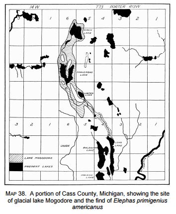 |
 RSS Feed